Rendered at 12:20:16 10/22/25


 “AN ACCURATE MAP OF ENGLAND and WALES\"-GUTHRIE")
 “AN ACCURATE MAP OF ENGLAND and WALES\"-GUTHRIE")
 “AN ACCURATE MAP OF ENGLAND and WALES\"-GUTHRIE")
 “AN ACCURATE MAP OF ENGLAND and WALES\"-GUTHRIE")
 “AN ACCURATE MAP OF ENGLAND and WALES\"-GUTHRIE")
 “AN ACCURATE MAP OF ENGLAND and WALES\"-GUTHRIE")
 “AN ACCURATE MAP OF ENGLAND and WALES\"-GUTHRIE")
 “AN ACCURATE MAP OF ENGLAND and WALES\"-GUTHRIE")
 “AN ACCURATE MAP OF ENGLAND and WALES\"-GUTHRIE")
 “AN ACCURATE MAP OF ENGLAND and WALES\"-GUTHRIE")
 “AN ACCURATE MAP OF ENGLAND and WALES\"-GUTHRIE")
 “AN ACCURATE MAP OF ENGLAND and WALES\"-GUTHRIE")
 “AN ACCURATE MAP OF ENGLAND and WALES\"-GUTHRIE")
 “AN ACCURATE MAP OF ENGLAND and WALES\"-GUTHRIE")
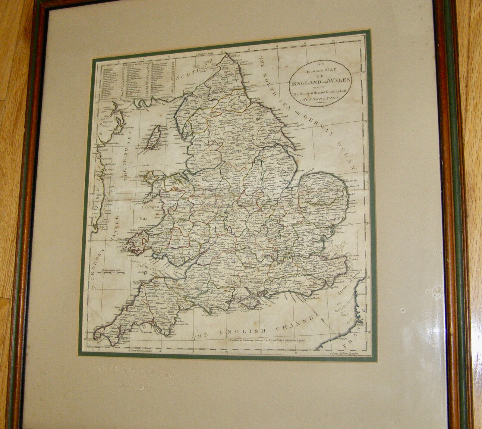
ANTIQUE ORIG. 18th CENTURY (1785) “AN ACCURATE MAP OF ENGLAND and WALES"-GUTHRIE
Ships from
United States

Share & earn! Sign in, share this or any listing, and you’ll get commission when it sells.
Learn more

Shipping options
Seller handling time is 4 business days Details
No shipping price specified to CA
Ships from
United States
Offer policy
OBO - Seller accepts offers on this item.
Details
Return policy
None: All purchases final
Purchase protection
Payment options
PayPal accepted
PayPal Credit accepted
Venmo accepted
PayPal, MasterCard, Visa, Discover, and American Express accepted
Maestro accepted
Amazon Pay accepted
Nuvei accepted
Item traits
| Category: | |
|---|---|
| Quantity Available: |
Only one in stock, order soon |
| Condition: |
Unspecified by seller, may be new. |
| Original/Reproduction: |
Antique Original |
| Year: |
1785 |
| Country/Region: |
England |
| Format: |
Atlas Map |
| Date Range: |
1785 |
| Type: |
PRINCIPLE ROADS from the BEST AUTHORITIES - GUTHRIE’S SYSTEM |
| Printing Technique: |
HAND COLORED MAP, COPPER PLATE |
| State: |
ENGLAND AND WALES |
| Cartographer/Publisher: |
June 15th 1785 by C. Dilly & G. Robinson, 1785 |
| City: |
PRINCIPLE ROADS from the BEST AUTHORITIES - GUTHRIE’S GEOGRAPHY |
| County: |
ENGLAND ans WALES |
Listing details
| Shipping discount: |
No combined shipping offered |
|---|---|
| Posted for sale: |
More than a week ago |
| Item number: |
1731425721 |
Item description
ANTIQUE ORIGINAL
18th CENTURY (1785)
?AN ACCURATE MAP OF ENGLAND and WALES w/ PRINCIPLE ROADS from the BEST AUTHORITIES -
GUTHRIE?S SYSTEM OF GEOGRAPHY" -
HAND COLORED MAP,
COPPER PLATE,
DOUBLE MATT,
FRAMED -
BY WILLIAM GUTHRIE [1708-1770] -
PUBLISHER: London : Published as the Act directs June 15th 1785 by C. Dilly G. Robinson, 1785. -
Spine title: Atlas : 1785. -
Cartographic data: Scale given as BRITISH STATUTE MILES -
RARE: + MOUNTED TO BACK OF FRAME:
+ INSTRUCTION PAGE TO BOOKBINDER FOR ORDER PLACEMENT IN ?THE ATLAS TO GUTHRIE?S SYSTEM OF GEOGRAPHY? -
EXTREMELY GOOD CONDITION,
WITH SOME WEAR TO THE MOUNTED PAGE AT THE BACK OF THE FRAME
MEASUREMENTS:
Framed Dimensions: 22 1/4 inches High x 20 1/2 inches Wide
56.5 x 52 cm
Sight Dimensions: 12 inches High x 12 3/4 inches Wide
34.5 x 32 cm
CONDITION: In Extremely Good Condition, not inspected out of the frame. There is some wear to the mounted page at the back of the frame, as well as hand written notations on this page. Please see photographs.
Please note: Shipping discounts will apply on additional items. Please see my other auctions.
Please note: Grading of Condition and Value:
Grading is a subjective art and does vary between individuals and experts alike.
We provide the best quality images that we can.
Based on these images, and your own level of experience, you should assign your own grade and valuation.
Terms of Sale:
By placing a bid on this item, you are stating to have read and agreed to all the terms listed in this listing.
This item is not sold on approval. All sales are final. You are responsible for your bid.
As color monitors vary from computer to computer, please ask questions if this is an issue for you.
INTERNATIONAL BUYERS ? Please Note:
Import
duties, taxes and charges are not included in the item price or
shipping charges. These charges are the buyer's responsibility.
Please check with your country's customs office to determine what these additional costs will be prior to bidding/buying.
Added to your wish list!

- ANTIQUE ORIG. 18th CENTURY (1785) “AN ACCURATE MAP OF ENGLAND and WALES"-GUTHRIE
- 1 in stock
- Price negotiable
- Handling time 4 days.
Get an item reminder
We'll email you a link to your item now and follow up with a single reminder (if you'd like one). That's it! No spam, no hassle.
Already have an account?
Log in and add this item to your wish list.