Rendered at 10:27:03 10/22/25


Sign up and get $15.00 bCredits free to use at checkout and another $5.00 bCredits when you make your first purchase. More info
Free Shipping
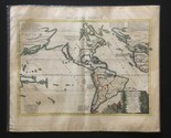
California is Island - Americas is Atlantis - Original Rare 1690 Sanson Map
$7,925.70 CAD
(It may be possible to pay only $5,635.00 instead of $5,650.00 when you
use your bCredits at checkout)
Sign up and get $15.00 bCredits free to use at checkout and another $5.00 bCredits when you make your first purchase. More info
Ships from
United States

Share & earn! Sign in, share this or any listing, and you’ll get commission when it sells.
Learn more
Shipping options
Seller handling time is 2 business days Details
No shipping price specified to CA
Ships from
United States
Offer policy
OBO - Seller accepts offers on this item.
Details
Return policy
Partial refund available within 30 days
Purchase protection
Payment options
PayPal accepted
PayPal Credit accepted
Venmo accepted
PayPal, MasterCard, Visa, Discover, and American Express accepted
Maestro accepted
Amazon Pay accepted
Nuvei accepted
Item traits
| Category: | |
|---|---|
| Quantity Available: |
Only one in stock, order soon |
| Condition: |
Unspecified by seller, may be new. |
| Original/Reproduction: |
Antique Original |
| Date Range: |
1600-1699 |
| Year: |
1690 |
| Cartographer/Publisher: |
Sanson & Mortier |
Listing details
| Seller policies: | |
|---|---|
| Shipping discount: |
Seller pays shipping for this item. |
| Posted for sale: |
More than a week ago |
| Item number: |
1751666055 |
Item description
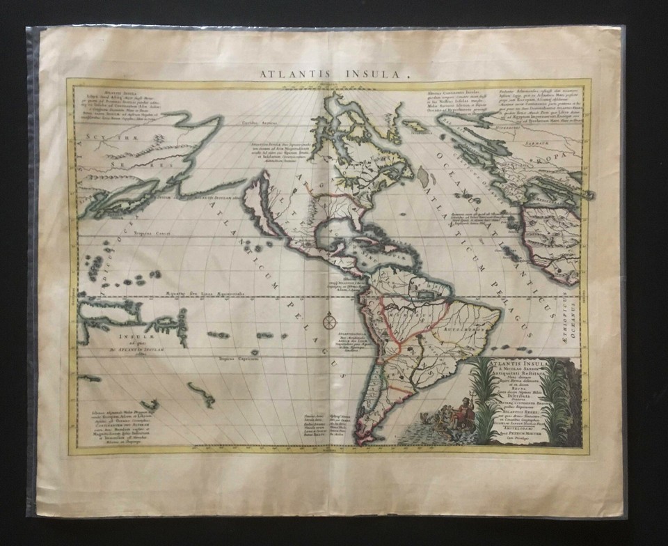
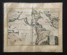
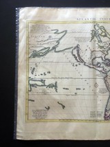
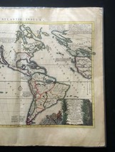
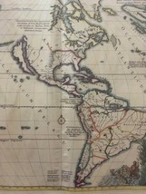
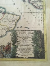
ATLANTIS INSULA a NICOLAO SANSON Antiquitati Restituta; Nunc
demum Majori Forma delineata, et in decem REGNA, Iuxta decem Neptuni Filios
Distributa. Praterea INSULÆ, NOSTRÆQ CONTINENTIS REGIONES quibus Imperavere
ATLANTICI REGES; aut quas Armis Tentavere. ex Conatibus Geographicis.
Gulielmi Sanson Nicolai Filii. Amstelodami Apud Petrum Mortier Cum Privilegio.
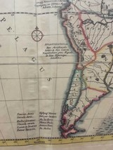
California as an Island - Atlantis
Insula - Map of New World as Atlantis
Amsterdam / 1690
By Sanson Mortier
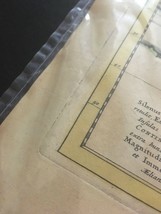
A very attractive map with bright original hand coloring (colored by hand).
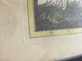
Two large sheets are joined at its vertical centerfold; the paper shows
normal even overall tone and is in nice condition. This is possibly the
engraved plate state three or four (of five). [Burden #405]
Margins have not been trimmed, having all its original full
wide margins present. Rare for this map.
Map: 21.5? x 15.3?
Plate: 22.0? x 16.2?
Sheet: 24.0? x 20.0?
Color outlined; slight toning; minor fraying at edges.
A FINE EXAMPLE AND A RARE MAP.
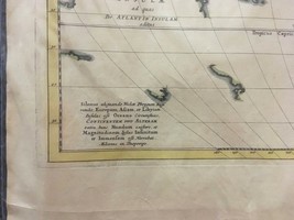
A strange mixture of myth and fact: America
is called 'The Island of Atlantis', and divided into regions named after the ten
sons of Neptune. California
is shown as an island and the Great Lakes are
open-ended in the west.
Sanson's fascinating map of the New
World as Plato's mythical Atlantis, divided among the 10 sons of
Neptune, who is featured in the elaborate title cartouche. California
is shown as a large island and northwestern North America/Atlantis extends all
the way to the land of the Scythians in Asia. A very unusual map, that purports to show the earth about
200,000 years ago before its settlement by humans. The god Neptune had divided
up the land masses among his ten sons.
Fascination with the Atlantis legend caused the map to sell
well from between 1669 and 1741. Atlantis was first described by Plato about
400 B.C. Interest in the lost continent or the Atlantian empire
continued unabated into the late 19th and 20th Centuries. Over the
next 2300 years, many other scholars and pseudo intellects championed various
elements of the legend.
This map depicts the Americas
with California shown as an island (a misconception which continued well in to
the 18th century). Unusual topography
on this map shows North America with the Great Lakes
still very misshapen and open-ended in the west. A large lake in the western
part of North America is the source of a river which empties into the sea
between the North American continent and naturally, California
is depicted as an Island. The map also
appeals to collectors because the Great Lakes
are shown as a thematic version of the prototype Sanson first published in
1650.
The map
shows the cartographic knowledge of the Western World as of the middle of the
17th Century, with California shown as an
island, the Dutch discoveries in Australia
and New Zealand and the
style mythical / conjectural configurations of Alaska,
Japan
and the lands between. Most
of the Asian European coastlines parts of New Guinea, New Zealand
and Australia
are shown. Mexico City Cuzco are noted (the capitals of the New
World). The map includes both Asian and European coastlines
and bits of New Guinea, New Zealand and Australia. This is a purely
topographical map and shows Machimos
Bellatrix (Mexico City) and Cuzco, the capitals of the New World.
There are such names as
Gadirus in present-day Canada,
Thule Insula for Iceland,
Altera Alta in the Southwest, Autochthon in Brazil, etc.
The title cartouche is surrounded by tall grass with the figure of Neptune
and his ten sons, and notes the Americas
as the mythical island of Atlantis!!
Nicolas
Sanson Biography
Nicholas
Sanson (1600-1667) is considered the father of French cartography in its golden
age from the mid-seventeenth century to the mid-eighteenth. Over the course of
his career he produced over 300 maps. His success can be chalked up to his
geographic and research skills, but also to his partnership with Pierre
Mariette. Nicolas Sanson, sometimes called Nicolas Sanson d'Abbeville or
Sanson d'Abbeville, was the most important French cartographer of the 17th
century. Tooley called Sanson "the founder of the French school of
cartography." He began making maps in the late 1620s. Sanson was official mapmaker to
Louis XIV. Because of his royal position, Sanson had access to official
French records of the explorations in the New World.
Pieter
Mortier Biography
Pierre, or
Pieter, Mortier (1661-1711) was a Dutch engraver, son of a French refugee. He
was born in Leiden.
In 1690 he was granted a privilege to publish French maps in Dutch lands. In
1693 he released the first and accompanying volume of the Neptune Francois. The
third followed in 1700. His son, Cornelis (1699-1783), would partner with
Johannes Covens I, creating one of the most important map publishing companies
of the eighteenth century.
BTC ETH XRP XLM DOGE LTC
Added to your wish list!
- California is Island - Americas is Atlantis - Original Rare 1690 Sanson Map
- 1 in stock
- Price negotiable
- Handling time 2 days.
- Returns/refunds accepted
Get an item reminder
We'll email you a link to your item now and follow up with a single reminder (if you'd like one). That's it! No spam, no hassle.
Already have an account?
Log in and add this item to your wish list.